Gingee Fort, Gingee
(Senji)
Gingee Fort or Senji Fort (also known as Chenji,
Jinji or Senchi) in Tamil Nadu, India is one of the surviving forts in Tamil Nadu, India. It lies in Villupuram District, 160 kilometers
(99 mi) from the state capital, Chennai, and is close to the Union Territory of Puducherry.


The fort is so fortified, that Shivaji, the Maratha king, ranked it as the "most impregnable fortress in India" and it was called the "Troy of the East" by the British. The nearest town with a railway station is Tindivanam and the nearest airport is Chennai (Madras), located 150 kilometers (93 mi) away.


Originally the site of a small fort built by the Chola dynasty during the 9th century AD, Gingee Fort was modified by Kurumbar during the 13th century. As per one account, the fort was built
during the 15–16th century by the Nayaks, the lieutenants of the Vijayanagara Empire and
who later became independent kings. The fort passed to the Marathas under the leadership of Shivaji in 1677 AD, Bijapur sultans, the Moghuls, Carnatic Nawabs, French and the British in 1761. The fort is closely associated with Raja Tej Singh,
who unsuccessfully revolted against the Nawab of Arcot and eventually lost his life in a battle.


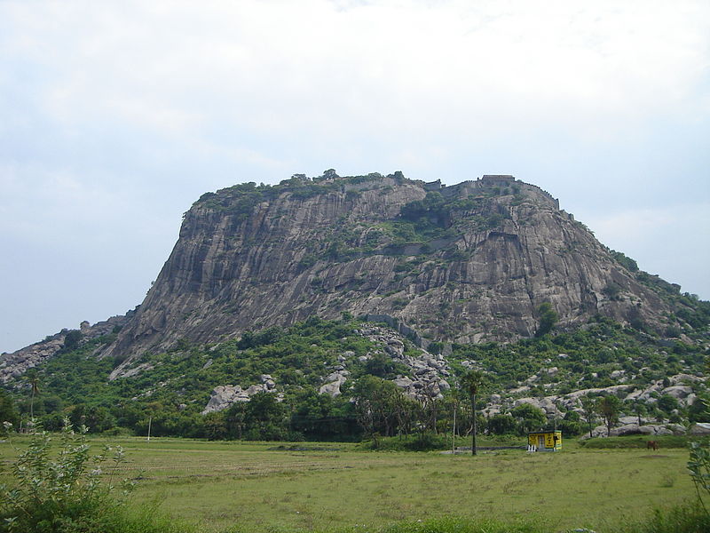
The Gingee Fort complex is on three hillocks: Krishnagiri to the
north, Rajagiri to the west and Chandrayandurg to the southeast. The three
hills together constitute a fort complex, each having a separate and
self-contained citadel. The fort walls are 13 km (8.1 mi) and the
three hills are connected by walls enclosing an area of 11 square kilometers
(4.2 sq mi). It was built at a height of 800 feet (240 m)
and protected by an 80 feet (24 m) wide moat.


The complex has a seven-storeyed Kalyana Mahal (marriage
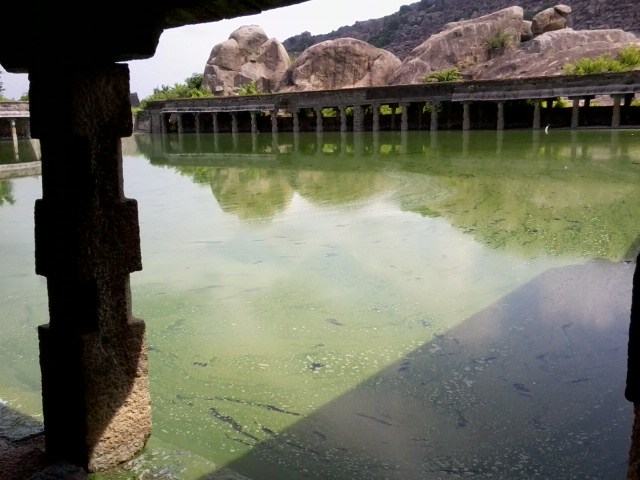
hall), granaries, prison cells, and a temple dedicated to its presiding Hindu goddess called Chenjiamman. The fortifications contain a
sacred pond known as Aanaikulam. On the top of the hillock, there are
minor fortifications. The fort, in modern times, is maintained and
administered by the Archaeological Survey of India. The fort is one of the prominent tourist destinations in
Villupuram district.


The fort complex is called ‘Troy of the East’, as the fort was
very effective in keeping attackers at bay that it earned the quality of being
‘impregnable’ just like Troy. The Gingee Fort complex has been a Monument of
national importance since 1921.
Geographical Position
Gingee Fort in Gingee is located at 12°14'32.5"N
79°23'60.0"E or 12.242346, 79.399990.
Legend and etymology
The Bijapur Nawabs who held the fort from about 1660 to 1677 AD called it
Badshabad, while the Marathas who succeeded them called it Chandry or Chindy.
The Mughals, on their capture of the fort in 1698 A.D., named it Nusratgadh
in honour of Nawab Zulfiqar Khan Nusrat-Jang, the commander-in-chief of the
besieging army. Later, the English and the French called it Gingee or Jinji.
The early Madras records of the English give the spelling Chingee or Chengey.
As per Tamil legend, the tragic tale of Raja Tej Singh, popularly known
in Tamil as Thesingu
Raasan, is associated with the fort. The true life story of Tej Singh and his
general, Mehboob Khan (aka Maavuthukaran), who were friends, has inspired many
poems, street plays, and countless other stories. He was the son of Swarup
Singh and revolted against the Nawab of Arcot, and was defeated and killed in the war that followed. Though
Gingee became a part of the Nawab's territory in 1714, the young and courageous
Tej Singh became a legend and his life, love and brave but tragic end were eulogized
in various ballads.
As a group, the seven goddesses are still said to guard the fort,
and each of the seven has a temple within the area. But three of the seven
stand for the rest as the immediate recipients of the actual sacrifice: two of
them, Kamalakkanniyamman and Kaliyamman (Kali), whose temples are within the
fort, and one, Mariayamman, who represents the town.
Accordingly, one male buffalo (erumaik kata) is sacrificed beside
an old and withered kattuvakai tree at a point near the fort granary and main
gate at the base of the Anandagiri (or Rajagiri). This point is said to mark
the fort's border (ellai). A second buffalo is then offered within minutes at a
crossroads on the way to the Mariayamman temple. Moreover, once the two
buffaloes are sacrificed, the icons (actually karakams) of Kamalakkanniyamman
(who is the main goddess of the fort) and Mariayamman are brought together in a
scene of great festivity so that the two "sisters" can meet,
"kiss," and romp about together, and in effect ritually affirm an
underlying identity that is repeatedly stressed by informants: that all seven
virgins, sisters, and goddesses are one and the same.
There are important reasons as to why each of these three
goddesses is evoked differentially: Mariayamman in connection with the town,
Kaliyamman in connection with scenes of possession and blood-drinking, and
Kamalakkanniyamman in connection with the fort. But so far it is essentially a
buffalo sacrifice associated with the royal fort; it is centered primarily on
Kamalakkanniyamman. It is her weapon: a silver culam, or trident that is
brought down from her temple and made symbolically present for the actual
sacrifices. In all this, it is clear that Kamalakkanni is linked primarily with Goddess Durga.
The buffalo sacrifices transpose into ritual Durga's feat of
killing the Buffalo Demon. In fact Kamalakkanniyamman is a form of Durga as
goddess of forts. And the festival, as a spring Navarathri, is itself
ultimately a festival of Durga. It is thus Kamalakkanniyamman as Durga who
allows us to define the unity of the seven goddesses.
It can be no accident that in the myth of the origins of the
Gingee Fort, the first sacrifice that takes place, the one which makes the
construction of the fort possible, is one that provides the required human
model. It is the same goddess or goddesses now receiving the offerings of
buffaloes, who originally instituted her own royal cult by the exemplary
sacrifice of the sage Tatikkara Virappan.
History
To know about the Fort from Pre-historic time clear evidence were
not available. With some of the collected details, historians framed the
history of Gingee Fort.
Living Place of Jains:
- B.C. to 6 A.D
In comparison with evidences available from other sources like the
evidence of rock-cut inscription of Jain monk Chandranandhi, from the figures
of twenty four Jaina Thirthankaras in Sinukadambur, from the figures of Jains
ascetics in Thirunathar hill and from the evidences of rock-cut beds of Jains
in the upper part of Krishnagiri hill and foot print on the hill top,
Chakkildurgam (or) Sangilidurgam, historians strongly believe that Jains lived
in Gingee from 200 B.C. in 500 A.D.
Gingee under the Pallavas:
- (600 A.D. to 900 A.D)
During the reign of the Pallavas a cave temple was excavated in
the natural hill in Singapuram. They built a temple in Panamalai which is to
the south of Gingee. In Mandagapattu, which is 17 kms, away from Gingee, a cave
temple was excavated in a rock. A rock inscription portrays Pallava
Mahendravarman (580 A.D. to 630 A.D.) as Vichitrachitha. We can conclude from
these evidences that Gingee was once under the rule of Pallava kings and also
the cave temples and rock inscriptions at Singavaram and Melacheri situated
near Gingee tell about the Pallava regime in Gingee.
Gingee under the rule
of Cholas: - (900 A.D. – 1103 A.D)
From the rock-cut inscriptions in Aanangur, East of Gingee, it is
known that after the decline of the Pallava kings, Gingee was under the control
of Adithya Chola (871 A.D. – 907 A.D.) Then during the reign of Adithya Chola
II and his brother Rajaraja Chola I (985 A.D- 1014 A.D.) it was called
“Singapuranadu”. From these evidences we come to know that Gingee was under the
rule of the Cholas.
Gingee under the rule
of Later Pandya, Pallava and Hoysalas: - (1014 A.D. – 1190 A.D)
From the Book “”Karnataka Rajakkal Savistara Charitham” British
Historian Mackenzie says that after the rule of the Cholas, Gingee came under
the supremacy of Pandya, Pallava and Hoysalas.
Gingee under Konar Heritage:
- (1190 A.D. – 1330 A.D)
Gingee was under the sway of chieftains, Anandha Kon, Krishna Kon
and Pullia Kon even though there were no Epigraphical evidences from Kon rule
but it is specified in some books. By foreign sources we come to know that
Anandha Kon built “Anandha Giri” and afterwards it became “Raja Giri” His son
Krishna Kon built “Krishna Giri”.
The main source for the first two hundred years of the history of
the place is the "Complete History of the Carnatic Kings" among the
Mackenzie manuscripts. According to historian Narayan, a small village called Melacheri,
located 3 mi (4.8 km) away from Gingee is called "Old
Gingee" has traces of fortifications from about 1200 AD. Ananda Kon
of the shepherd community (Konar) accidentally found a treasure in one of the
cavities of the Western hill while grazing his sheep. Making himself the head
of a small band of warriors, he defeated the petty rulers of the neighbouring
villages and built a small fortress on Kamalagiri, which he renamed Anandagiri
after himself.
The Konar dynasty ruled Gingee from 1190 to 1330 AD, and was
succeeded by the chief of a neighbouring place called Kobilingan, who belonged
to the Kurumbar caste and ascended the throne of Gingee. He was a feudatory of
the powerful Cholas. Gingee came into the hands of various ruling dynasties
of South India, starting from the Cholas.
Originally the site of a small fort built by the Chola dynasty during the 9th century AD, Gingee Fort was modified by Kurumbar while fighting the Cholas and again by the Vijayanagar Empire during
the 13th century.
Recorded history goes back to the 16th century, when Gingee became
the seat of the Nayaka rulers, who were under the lordship of the expanding
Vijayanagar Empire. Krishnadevaraya appointed Krishnappa Nayaka, and he was
considered the founder of the Nayaka line of Gingee. The fort was built at a
strategic place to fend off any invading armies. It was further strengthened by
the Marathas under the leadership of Shivaji in 1677 AD. He recaptured it from the Bijapur sultans who had originally taken control of the fort from the
Marathas.
During Aurangzeb's campaign in the Deccan, Shivaji's second son who had assumed the throne, Chatrapathi Rajaram,
escaped to Gingee and continued the fight with Moghuls from Gingee. The fort
was the seat of the Maratha Empire for a few months. The Moghuls could not
capture the fort for seven years in spite of laying siege. The fort was finally
captured in 1698, but not before Chatrapathi Rajaram escaped. It was later
passed on to the Carnatic Nawabs who
lost it to the French in 1750 before
the British finally took control
in 1761 despite losing it to Hyder Ali for a brief period. Raja Desinghu ruled Chenji during the
18th century.
Most of the structures, fortification walls and temples were built
during this period. Surrounded by high walls, it was so strategically planned
as to make enemies think twice before they attacked. The fort was built as a
strategic place of fending off any invading Muslim armies. Strongly guarded by
a triple gate beyond which lay equally heavily guarded courts, the summit of
the Rajagiri could not have been easily attained by any of the enemies. The
fortifications and defenses were further strengthened under Chatrapathi
Shivaji, the great Maratha ruler in 1677 A. D., who recaptured it from the
Bijapur sultans who had originally taken control of the fort from the Marathas.
A place of great historic interest, this fort was so well fortified that Shivaji ranked it as the "most impregnable fortress in India" and the British called it the "Troy of the East". However, after the fort passed into British hands, it did not see any further advancement and was declared as a National Monument in 1921 and was under the Archeological Department.
A place of great historic interest, this fort was so well fortified that Shivaji ranked it as the "most impregnable fortress in India" and the British called it the "Troy of the East". However, after the fort passed into British hands, it did not see any further advancement and was declared as a National Monument in 1921 and was under the Archeological Department.
Recently the Tourism Department of India has tried to popularize
this remote and often forgotten fort in Tamil Nadu. Gingee today, with its
ruined forts, temples and granaries, presents a different picture from the
glorious splendor of its bygone days. But the remains of that glorious past,
speak volumes about the numerous invasions, warfare and bravery that it
witnessed.
Architecture
The Gingee Fort complex is on three hillocks: Krishnagiri to the
north, Rajagiri to the west and Chandrayandurg to the southeast. The three
hills together constitute a fort complex, yet each hill contains a separate and
self-contained citadel. Connecting them — forming an enormous triangle, a mile
from north to south, punctuated by bastions and gateways giving access to the
protected zones at the heart of the complex. The fort walls are 13 km
(8.1 mi) and the three hills are connected by walls enclosing an area of
11 square kilometers (4.2 sq mi).


It was built at a height of 800 feet (240 m) and protected by
an 80 feet (24 m) wide moat. It has a seven-storeyed Kalyana Mahal (marriage hall), granaries, prison cells, and a temple dedicated to its presiding Hindu goddess called Chenjiamman. The fortifications contain a
sacred pond known as Aanaikulam. The walls of the fort are a mixture of
the natural hilly terrain comprising the Krishnagiri, Chakkilidrug and Rajagiri
hills, while the gaps were sealed with the main wall that measures 20 metres
(66 ft) in thickness. On the top of the hillock, there are minor
fortifications.


Water resources are usually sparse in South Indian forts, while it
was well managed in the Citadel. There are two sweet water sources on the
summit and below it there are three reservoirs for storage of rain water. Water
for Kalyana Mahal was brought through earthenware pipes from reservoir located
500 m (1,600 ft) from it.


It has three defensive lines, all with powerful gateways, and two
with triple arches. The route to the citadel is defended by seven gateways;
three of the gates in the second and fourth walls have large courtyards between
them. The first gate has a barbican and moat crossed by a drawbridge, but the
courtyard walls are destroyed. Over the lintel of the second gate is a small
circular carving of Kirtimukha - 'Mouth of Glory'-with a demonic head. The
gateways in the curtain walls are staggered in the classic mediaeval pattern to
enable the defence to delay an enemy advance.
The walls of the fort are a mixture of the natural hilly terrain
comprising the Krishnagiri, Chakkilidrug and Rajagiri hills, while the gaps
were sealed with the main wall that measures 20 metres (66 ft) in thickness.
The Kalyana Mahal is built in the Indo-Islamic style and is one of
the most attractive ruins in the fort. It is a square courtyard surrounded by
chambers with a large central tower of eight storeys resembling a beehive. In
the middle of the court is 27 metre high square tower with a pyramidal roof.
Each storey, except the highest two, comprises a small room surrounded by an
arcaded veranda. These rooms were used by the ladies of the Governor's
household.
It can be said about the Gingee Fort that most of the buildings
and structures in the fort complex were raised by the successive rulers of
Gingee belonging to the Vijayanagara, Nayaka, Maratha, Mughal, Carnatic Nawab,
the French and British families during the period from 1383 to 1780 AD.
There is a sophisticated system of water supply via earthenware
pipes connected to large reservoirs. Other features of interest include the
Raja's Bathing Stone, a large granite block near where the palace once stood,
and a huge gun crowning Rajagiri.
Rajagiri:
There were three such forts and most prominent of the three was
called the ‘Rajagiri’ seems to have held the most importance. The other two are
called, Krishnagiri and Chakkiliya Durg. These forts had granaries, prison
cells, outposts, canon stations, places of worship like temples and mosques,
artillery stores and living rooms. The main fort had a bell tower, canon tower,
and even had a seven storey marriage hall, traditionally called Kalyana
mandapam. The temple on the hill has been quite popular with the local
inhabitants for ages and is dedicated to the goddess of the Hill, fondly called
Chenjiamman or Mother of Chenji.


A pond is found within the premises
called Aanaikulam thought to have been a bath for the troop of war
elephants stationed at the fort. A prison well can be still seen here where
prisoners are believed to have starved in their pre-designed graves. A museum
is now maintained by the ASI in the main fort to attract tourists.
The first hill, where the main fort is, is called Rajagiri.
Originally it was known as Kamalagiri as well as Anandagiri. The fort was
historically considered most impregnable. It is about 800 feet (240 m) in
height. Its summit is cut off from communication and is surrounded by a deep,
natural chasm that is about 10 yards (9.1 m) wide and 20 yards (18 m)
deep. To gain entry into the citadel one had to cross the chasm with the help of a small wooden
draw bridge.
The naturally strong rock where the fortress is located is further
strengthened by the construction of embrasure walls and gateways along all possible shelves and precipitous
edges. The citadel is reached by traversing through seven gates. This citadel
contains important buildings apart from the living quarters of the royalty,
like the stables, granaries, and meeting halls for the public, temples,
mosques, shrines and pavilions. Kamalakkanni Amman temple is present at the top
of Rajagiri hills.
As per Hindu legend, the presiding deity, Kamalakkanni, is
believed to be the widow of demon king Acalamaccuran. Draupadi, a Hindu goddess, beheaded the hundred heads of the demon and Kamalakkanni
is believed to have protests that she would become a widow. Draupadi explains
her similarities that she has no sexual relations, though married. This
resulted in the ambiguous kanni suffix. Ranganathar Temple, bell tower,
watch tower, cannon and Draw Bridge are located atop the hill.
The lower fort consists of Arcot Gate, Pondicherry Gate, which was
probably improved by the French during their occupation (1751–1761), the Prison
on top of Pondicherry Gate, Royal Battery, Venkataramanaswami Temple, Pattabhi
Ramaswami Temple, Sadatulla Khan’s mosque, Chettikulam and Chakrakulam tanks,
platform where Raja Desing was killed in a war, large stone image of Hanuman, prisoner’s well where the prisoners condemned to death were
thrown and left to die of starvation.
The inner fort consists of Kalyana Mahal, the royal stables, the
ruined royal palace, Aanaikulam tank, granaries, magazine and the shrine of
Venugopalaswami. There is a site museum at the entrance of the fort set up by
the Archaeological Survey of India containing sculptures pertaining to periods and many
dynasties that ruled Gingee. There are also guns and cannonballs made of stone,
strewn about the fort.
Krishnagiri:
Krishnagiri or the English Mountain was the main base of the
English army when they had the fort complex under their control. This smaller
fort is accessed by granite steps from the ledge that connects it to the main
fort. It houses many artifacts from the time of the British regime.


The second important hillock with an imposing citadel is known as
Krishnagiri. It lies to the North of Thiruvannamalai road. It is smaller in size and height compared to the
Rajagiri fort. Another fort connected with Rajagiri with a low rocky ridge is
called Chandrayan Durg, Chandragiri or St. George’s Mountain. The military and
strategic value of this fort has been relatively less, but it has some
interesting buildings of later period.
Chakkiliya Durg:
The third fort Chakkiliya Durg was where cobblers and saddle
makers for the army were based under the British.

The third fort for some reason is called Chakkiliya Durg or Chamar
Tikri — meaning the fort of the cobblers. It is not known why it had acquired
the name. Probably the royal saddlers and military shoemakers had set up their
workshops here, as Gingee obviously was a military encampment. There is a
smaller and less important fourth hill, the summit of which is also well
fortified. There is nothing much left of Chandrayan Durg and Chakkilli Durg.
Their flanks are now completely covered with thorny shrubs and stone pieces.
Kalyana Mahal:
The Kalyana Mahal is one of the most attractive ruins in the fort
that is built in Indo-Islamic style. It consists of a square court, surrounded
by rooms for the ladies of the Governors household. In the middle of this court,
there is a 27-meter high square tower, built of stone. The tower has a
pyramidal roof. The rooms in this tower are very similar to other Vijayanagar
Nayaka buildings elsewhere.


Sacred Pond:
The fortifications contain a sacred pond known as Aanaikulam, on
the way to the Hanuman temple. Chakkarakulam and Chettikulam are the two famous
ponds in this fort. Chettikulam was built by Raja Shetty during the Maratha
occupation of the place, towards the end of the 18th century. To the north of
this pond is a platform believed to be Raja Desinghu funeral pyre, where his
young wife committed sati.


Venkatramana Temple:
Located to the west of the inner gate of the lower citadel, the
temple contains a remarkable sculpture depicting Lord Krishna playing on the
flute with is two consorts. This is the largest temple in Gingee, which was
built by Muthiah Nayaka in 1550 AD. Another interesting feature in this temple
is a finely polished, broad smooth slab found in front of the temple.

Ranganatha Temple:
Built in typical Indo-Islamic style, the Audience hall is a
damaged roof supported by a series of graceful little pointed arches. The
Magazine building is also a noteworthy structure. Built in typical Vijayanagar
style, is the famous Ranganatha Temple. To the south of the watchtower, big
iron cannon is located, roughly 4 meters long, and 2 meters in circumference.
In style and form, this cannon is very similar to the Malik-1-Maidan of
Bijapur.


Barracks &
Stables:
On the western side of the Kalyana Mahal one can see a series of
low vaulted and arched cells that are referred to as the Barracks and Stables,
but now it has been converted into Archaeological Conservation Training camp.

Gymnasium &
Granary:
It is the largest granary built in stone with a spacious entrance
passage and its walls are nearly 2 metres thick. A stone structure, with
barrel-vaulted roof, found on the Northern-Eastern side of the granary is said
to be the Gymnasium.


Sad-At-Ullam Khan
Mosque:
This Mosque is located at the entrance of the inner fort of
Rajagiri & was erected by Sad-at-Ullah Khan to commemorate his victory over
De Singh and the capture of the fort in 1713 AD. According to a Persian
inscription found here, the mosque is said to have been constructed in
1717-1718 AD.


Prisoner`s Well:
Situated behind the Chakkaraikulam on the Rajagiri hill, this low
circulation brick well is said to be the place where prisoners were thrown and
left to die of starvation. Bathtubs with continuous supply of water, huge
cannon on the top of the fort near Chakrakulam-Kunda (reservoir) are a treasure
for the tourists.

Other buildings and structures in the fort complex were raised by
the successive rulers of Gingee belonging to the Vijayanagar, Nayaka, Maratha,
Mughal, Carnatic Nawab, the French and British families during the period from
1383 to 1780 AD.
Culture
After the fort passed into British hands, it did not see any
further action. The fort at Gingee was declared a National Monument in 1921 and
was under the Archaeological Department. The Tourism Department of India has
tried to popularize this remote and oft-forgotten fort. Gingee today, with its
ruined forts, temples and granaries, presents a different picture from the
glorious splendor of its bygone days.
But the remains of that glorious past speak volumes about the
numerous invasions, warfare and bravery that it witnessed. The fort is maintained by the
Archaeological Department. An entry charge of ₹5 is charged for Indian
citizens and SAARC countries and US$2 or ₹100 for all monuments
inside Krishnagiri and Rajagiri forts.


Gingee Fort also known as Chenji or Jinji in Tamilnadu dates back
to the 9th century when the Cholas had a very strong hold on it. But the fort
as it looks today is the handiwork of the Vijayanagar kings who made it an
unconquerable monument. This fort is one of the few surviving forts in Tamil
Nadu and is much more popular for its temples than forts. This fort lies in
Villupuram district, 160 km from the state capital, Chennai and is close to the
union territory of Pondicherry.
Useful Information
Visiting Hours: 9 am to 5 pm
Ticket Issuing Hours: 9 am to 4:30 pm
Entry Restricted
After: 4:30 pm
Entry
Fee:
For Citizen of India - Rs.5/-
For Foreigners: Rs.100/-
Entry free for Childrens below 15 years.
Connectivity
Gingee is a Panchayath town in Villupuram district (South Arcot
district) in the Indian state of Tamil Nadu which is located on the Tindivanam
to Thiruvannamalai road about 25 km from Tindivanam.
·
160 km from Chennai.
·
65 km from Puducherry (Pondicherry).
The nearest town with a railway station is Tindivanam and Villupuram.
The nearest airport is Chennai 160km (Madras).
